Don't worry, population control comes through prosperity not bullets or nukes.The U.S. Is Mindlessly Marching Toward War With Russia

The U.S. Is Mindlessly Marching Toward War With Russia
There’s been a shift in Washington. The talk is no longer about sanctions on Moscow but how best to escalate U.S. involvement in the war.thefederalist.com
Is this part of Biden and Companies way to fight climate change ??
It's Climate Change I tell'ya!! IT'S CLIMATE CHANGE!!
- Thread starter B00Mer
- Start date
You are using an out of date browser. It may not display this or other websites correctly.
You should upgrade or use an alternative browser.
You should upgrade or use an alternative browser.


Disease and starvation just don't seem to do the job. The Four Horsemen ain't very effective.Don't worry, population control comes through prosperity not bullets or nukes.
"The Four Mounties of Just Another Tuesday" don't have quite the same ring to it.4 Mounties?
Sigh. You people have no sense of drama (except when you're whimpering about how hard-done-by y'all are).
It's not Mounties in red serge, it's
THE RED SURGE!
It's not Mounties in red serge, it's
THE RED SURGE!
Disease and starvation just don't seem to do the job. The Four Horsemen ain't very effective.
Sadly that joke may actually become real with food shortages in 3rd world countries
Luckily we are in North America where the rich are slim and healthy and the poor are obese.Sadly that joke may actually become real with food shortages in 3rd world countries
Manic Monday ."The Four Mounties of Just Another Tuesday" don't have quite the same ring to it.

Landslide on central B.C. coast caused lake tsunami more than 100 metres high: Study
'Imagine a landslide with a mass equal to all of the automobiles in Canada, travelling with a velocity of about 140 kilometres an hour when it runs into a large lake,' says UNBC's Dr. Marten Geertsema.
Author of the article:Tiffany Crawford
Publishing date:Mar 30, 2022 • 1 day ago • 3 minute read • Join the conversation
The aftermath of a landslide that devastated salmon habitat in Elliot Creek and the Southgate River in central B.C. in 2020.
The aftermath of a landslide that devastated salmon habitat in Elliot Creek and the Southgate River in central B.C. in 2020. PHOTO BY UNBC /PNG
Article content
A landslide in a rural part of the central B.C. coast two years ago displaced enough water to cause a tsunami more than 100 metres high, according to a study by the University of Northern B.C.
Advertisement 2
STORY CONTINUES BELOW
Article content
Nutrition in adolescence is the foundation for adult health
Trackerdslogo
On Nov. 28, 2020, the landslide near the West Grenville Glacier in a remote valley resulted in “catastrophic damage” to the land and waterways in Homalco First Nation territory, according to a news release from UNBC.
New research from UNBC scientists, in partnership with the Hakai Institute and B.C.’s Forests Ministry, and published in the journal Geophysical Research Letters, found that a rare cascade of events in the southern Coast Mountains caused a landslide that triggered the tsunami in a glacial lake and then flooding.
The report says this caused extensive damage to the salmon habitat in Elliot Creek and the Southgate River.
Flood water, organic debris and fine sediment entered a fiord where it produced a more than 60-kilometre-long sediment plume. That changed the water temperature, water chemistry and amount of suspended solids in the water for weeks, the report said, destroying forest and salmon spawning habitat.
Advertisement 3
STORY CONTINUES BELOW
Article content
According to the Hakai Institute, when the slide hit Elliot Lake “50 million tonnes of rock — roughly equal in weight to 150 Empire State Buildings — dropped from a sheer mountainside.”
Photos from the November 2020 landslide into Elliot Creek in central B.C. Photo credit: Hakai Institute.
Photos from the November 2020 landslide into Elliot Creek in central B.C. Photo credit: Hakai Institute. PHOTO BY HAKAI INSTITUTE /PNG
Photos from the November 2020 landslide into Elliot Creek in central B.C. Photo credit: Hakai Institute.
Photos from the November 2020 landslide into Elliot Creek in central B.C. Photo credit: Hakai Institute. PHOTO BY HAKAI INSTITUTE /PNG
The science team used various observations, including seismic energy, laser mapping, satellite imagery and state-of-the-art computer simulations, according to UNBC.
“Imagine a landslide with a mass equal to all of the automobiles in Canada, travelling with a velocity of about 140 kilometres an hour when it runs into a large lake,” said the lead author, Marten Geertsema, who is an adjunct professor in UNBC’s ecosystem science and management program.
Geertsema said the landslide displaced enough water to cause a tsunami with a wave height that exceeded 100 m.
Advertisement 4
STORY CONTINUES BELOW
Article content
“This drained most of the lake water, which then travelled down (a 10-km)-long channel causing widespread channel erosion and loss of salmon habitat,” he said. “It took about 30 seconds from when the rock started to detach on the slope for that mass of rock to enter the lake and, that produced a huge displacement wave. And everything was removed, all the trees and the soil, and so that was pretty spectacular.”
The region had been soaked in up to 103 millimetres of rain in the week leading to the landslide, while snowmelt may have also contributed up to 30 mm of water, the report said. Other factors the researchers say led to the slide were fractured bedrock at the base of the slope due to glacier retreat.
The report said this kind of hazard in high mountains can happen as a result of rapid deglaciation.
Advertisement 5
STORY CONTINUES BELOW
Article content
“It’s certainly consistent with what we might expect under a changing climate,” Brian Menouno, a UNBC geography professor and co-author of the study, said.
He said these landslides can occur when the glacial ice fills some of these valleys and the supports of these steep, unstable slopes are removed.
“Then those steep unstable slopes are susceptible to failure. And that’s what we think happened. We’re still not entirely certain what the actual trigger was, but we know that the removal of that ice played an important role.”
Both Menounos and Geertsema said their work couldn’t have been done without the partnership of the Homalco First Nations and the data from the Hakai Institute.
The study notes that while landslides and outburst floods aren’t new in the mountain regions, salmon are now experiencing low returns because of a variety of factors, including climate change and habitat degradation.
“Under a warmer climate, we know glaciers are continuing to retreat. And will continue to do that, in large part due to greenhouse-gas emissions. And as they do that, they expose not only steep terrain, but they can also start to expose areas where there are large lakes,” said Menounos.
Landslides have created tsunamis before. For example, there was one on Mount Colonel Foster on Vancouver Island just over five years ago and it created a 50 m wave.
Photos from the November 2020 landslide into Elliot Creek in central B.C. Photo credit: Hakai Institute.
Photos from the November 2020 landslide into Elliot Creek in central B.C. Photo credit: Hakai Institute. PHOTO BY HAKAI INSTITUTE /PNG
Photos from the November 2020 landslide into Elliot Creek in central B.C. Photo credit: Hakai Institute.
Photos from the November 2020 landslide into Elliot Creek in central B.C. Photo credit: Hakai Institute. PHOTO BY HAKAI INSTITUTE /PNG
Photos from the November 2020 landslide into Elliot Creek in central B.C. Photo credit: Hakai Institute.
Photos from the November 2020 landslide into Elliot Creek in central B.C. Photo credit: Hakai Institute. PHOTO BY HAKAI INSTITUTE /PNG
ticrawford@postmedia.com


 hakai.org

 torontosun.com
'Imagine a landslide with a mass equal to all of the automobiles in Canada, travelling with a velocity of about 140 kilometres an hour when it runs into a large lake,' says UNBC's Dr. Marten Geertsema.
Author of the article:Tiffany Crawford
Publishing date:Mar 30, 2022 • 1 day ago • 3 minute read • Join the conversation
The aftermath of a landslide that devastated salmon habitat in Elliot Creek and the Southgate River in central B.C. in 2020.
The aftermath of a landslide that devastated salmon habitat in Elliot Creek and the Southgate River in central B.C. in 2020. PHOTO BY UNBC /PNG
Article content
A landslide in a rural part of the central B.C. coast two years ago displaced enough water to cause a tsunami more than 100 metres high, according to a study by the University of Northern B.C.
Advertisement 2
STORY CONTINUES BELOW
Article content
Nutrition in adolescence is the foundation for adult health
Trackerdslogo
On Nov. 28, 2020, the landslide near the West Grenville Glacier in a remote valley resulted in “catastrophic damage” to the land and waterways in Homalco First Nation territory, according to a news release from UNBC.
New research from UNBC scientists, in partnership with the Hakai Institute and B.C.’s Forests Ministry, and published in the journal Geophysical Research Letters, found that a rare cascade of events in the southern Coast Mountains caused a landslide that triggered the tsunami in a glacial lake and then flooding.
The report says this caused extensive damage to the salmon habitat in Elliot Creek and the Southgate River.
Flood water, organic debris and fine sediment entered a fiord where it produced a more than 60-kilometre-long sediment plume. That changed the water temperature, water chemistry and amount of suspended solids in the water for weeks, the report said, destroying forest and salmon spawning habitat.
Advertisement 3
STORY CONTINUES BELOW
Article content
According to the Hakai Institute, when the slide hit Elliot Lake “50 million tonnes of rock — roughly equal in weight to 150 Empire State Buildings — dropped from a sheer mountainside.”
Photos from the November 2020 landslide into Elliot Creek in central B.C. Photo credit: Hakai Institute.
Photos from the November 2020 landslide into Elliot Creek in central B.C. Photo credit: Hakai Institute. PHOTO BY HAKAI INSTITUTE /PNG
Photos from the November 2020 landslide into Elliot Creek in central B.C. Photo credit: Hakai Institute.
Photos from the November 2020 landslide into Elliot Creek in central B.C. Photo credit: Hakai Institute. PHOTO BY HAKAI INSTITUTE /PNG
The science team used various observations, including seismic energy, laser mapping, satellite imagery and state-of-the-art computer simulations, according to UNBC.
“Imagine a landslide with a mass equal to all of the automobiles in Canada, travelling with a velocity of about 140 kilometres an hour when it runs into a large lake,” said the lead author, Marten Geertsema, who is an adjunct professor in UNBC’s ecosystem science and management program.
Geertsema said the landslide displaced enough water to cause a tsunami with a wave height that exceeded 100 m.
Advertisement 4
STORY CONTINUES BELOW
Article content
“This drained most of the lake water, which then travelled down (a 10-km)-long channel causing widespread channel erosion and loss of salmon habitat,” he said. “It took about 30 seconds from when the rock started to detach on the slope for that mass of rock to enter the lake and, that produced a huge displacement wave. And everything was removed, all the trees and the soil, and so that was pretty spectacular.”
The region had been soaked in up to 103 millimetres of rain in the week leading to the landslide, while snowmelt may have also contributed up to 30 mm of water, the report said. Other factors the researchers say led to the slide were fractured bedrock at the base of the slope due to glacier retreat.
The report said this kind of hazard in high mountains can happen as a result of rapid deglaciation.
Advertisement 5
STORY CONTINUES BELOW
Article content
“It’s certainly consistent with what we might expect under a changing climate,” Brian Menouno, a UNBC geography professor and co-author of the study, said.
He said these landslides can occur when the glacial ice fills some of these valleys and the supports of these steep, unstable slopes are removed.
“Then those steep unstable slopes are susceptible to failure. And that’s what we think happened. We’re still not entirely certain what the actual trigger was, but we know that the removal of that ice played an important role.”
Both Menounos and Geertsema said their work couldn’t have been done without the partnership of the Homalco First Nations and the data from the Hakai Institute.
The study notes that while landslides and outburst floods aren’t new in the mountain regions, salmon are now experiencing low returns because of a variety of factors, including climate change and habitat degradation.
“Under a warmer climate, we know glaciers are continuing to retreat. And will continue to do that, in large part due to greenhouse-gas emissions. And as they do that, they expose not only steep terrain, but they can also start to expose areas where there are large lakes,” said Menounos.
Landslides have created tsunamis before. For example, there was one on Mount Colonel Foster on Vancouver Island just over five years ago and it created a 50 m wave.
Photos from the November 2020 landslide into Elliot Creek in central B.C. Photo credit: Hakai Institute.
Photos from the November 2020 landslide into Elliot Creek in central B.C. Photo credit: Hakai Institute. PHOTO BY HAKAI INSTITUTE /PNG
Photos from the November 2020 landslide into Elliot Creek in central B.C. Photo credit: Hakai Institute.
Photos from the November 2020 landslide into Elliot Creek in central B.C. Photo credit: Hakai Institute. PHOTO BY HAKAI INSTITUTE /PNG
Photos from the November 2020 landslide into Elliot Creek in central B.C. Photo credit: Hakai Institute.
Photos from the November 2020 landslide into Elliot Creek in central B.C. Photo credit: Hakai Institute. PHOTO BY HAKAI INSTITUTE /PNG
ticrawford@postmedia.com
The Big Slide
hakai.org
Landslide on central B.C. coast caused lake tsunami more than 100 metres high: Study
'Imagine a landslide with a mass equal to all of the automobiles in Canada, travelling with a velocity of about 140 kilometres an hour when it runs into a large lake,' says UNBC's Dr. Marten Geertsema.
Old news recycled .Landslide on central B.C. coast caused lake tsunami more than 100 metres high: Study
'Imagine a landslide with a mass equal to all of the automobiles in Canada, travelling with a velocity of about 140 kilometres an hour when it runs into a large lake,' says UNBC's Dr. Marten Geertsema.
Author of the article:Tiffany Crawford
Publishing date:Mar 30, 2022 • 1 day ago • 3 minute read • Join the conversation
The aftermath of a landslide that devastated salmon habitat in Elliot Creek and the Southgate River in central B.C. in 2020.
The aftermath of a landslide that devastated salmon habitat in Elliot Creek and the Southgate River in central B.C. in 2020. PHOTO BY UNBC /PNG
Article content
A landslide in a rural part of the central B.C. coast two years ago displaced enough water to cause a tsunami more than 100 metres high, according to a study by the University of Northern B.C.
Advertisement 2
STORY CONTINUES BELOW
Article content
Nutrition in adolescence is the foundation for adult health
Trackerdslogo
On Nov. 28, 2020, the landslide near the West Grenville Glacier in a remote valley resulted in “catastrophic damage” to the land and waterways in Homalco First Nation territory, according to a news release from UNBC.
New research from UNBC scientists, in partnership with the Hakai Institute and B.C.’s Forests Ministry, and published in the journal Geophysical Research Letters, found that a rare cascade of events in the southern Coast Mountains caused a landslide that triggered the tsunami in a glacial lake and then flooding.
The report says this caused extensive damage to the salmon habitat in Elliot Creek and the Southgate River.
Flood water, organic debris and fine sediment entered a fiord where it produced a more than 60-kilometre-long sediment plume. That changed the water temperature, water chemistry and amount of suspended solids in the water for weeks, the report said, destroying forest and salmon spawning habitat.
Advertisement 3
STORY CONTINUES BELOW
Article content
According to the Hakai Institute, when the slide hit Elliot Lake “50 million tonnes of rock — roughly equal in weight to 150 Empire State Buildings — dropped from a sheer mountainside.”
Photos from the November 2020 landslide into Elliot Creek in central B.C. Photo credit: Hakai Institute.
Photos from the November 2020 landslide into Elliot Creek in central B.C. Photo credit: Hakai Institute. PHOTO BY HAKAI INSTITUTE /PNG
Photos from the November 2020 landslide into Elliot Creek in central B.C. Photo credit: Hakai Institute.
Photos from the November 2020 landslide into Elliot Creek in central B.C. Photo credit: Hakai Institute. PHOTO BY HAKAI INSTITUTE /PNG
The science team used various observations, including seismic energy, laser mapping, satellite imagery and state-of-the-art computer simulations, according to UNBC.
“Imagine a landslide with a mass equal to all of the automobiles in Canada, travelling with a velocity of about 140 kilometres an hour when it runs into a large lake,” said the lead author, Marten Geertsema, who is an adjunct professor in UNBC’s ecosystem science and management program.
Geertsema said the landslide displaced enough water to cause a tsunami with a wave height that exceeded 100 m.
Advertisement 4
STORY CONTINUES BELOW
Article content
“This drained most of the lake water, which then travelled down (a 10-km)-long channel causing widespread channel erosion and loss of salmon habitat,” he said. “It took about 30 seconds from when the rock started to detach on the slope for that mass of rock to enter the lake and, that produced a huge displacement wave. And everything was removed, all the trees and the soil, and so that was pretty spectacular.”
The region had been soaked in up to 103 millimetres of rain in the week leading to the landslide, while snowmelt may have also contributed up to 30 mm of water, the report said. Other factors the researchers say led to the slide were fractured bedrock at the base of the slope due to glacier retreat.
The report said this kind of hazard in high mountains can happen as a result of rapid deglaciation.
Advertisement 5
STORY CONTINUES BELOW
Article content
“It’s certainly consistent with what we might expect under a changing climate,” Brian Menouno, a UNBC geography professor and co-author of the study, said.
He said these landslides can occur when the glacial ice fills some of these valleys and the supports of these steep, unstable slopes are removed.
“Then those steep unstable slopes are susceptible to failure. And that’s what we think happened. We’re still not entirely certain what the actual trigger was, but we know that the removal of that ice played an important role.”
Both Menounos and Geertsema said their work couldn’t have been done without the partnership of the Homalco First Nations and the data from the Hakai Institute.
The study notes that while landslides and outburst floods aren’t new in the mountain regions, salmon are now experiencing low returns because of a variety of factors, including climate change and habitat degradation.
“Under a warmer climate, we know glaciers are continuing to retreat. And will continue to do that, in large part due to greenhouse-gas emissions. And as they do that, they expose not only steep terrain, but they can also start to expose areas where there are large lakes,” said Menounos.
Landslides have created tsunamis before. For example, there was one on Mount Colonel Foster on Vancouver Island just over five years ago and it created a 50 m wave.
Photos from the November 2020 landslide into Elliot Creek in central B.C. Photo credit: Hakai Institute.
Photos from the November 2020 landslide into Elliot Creek in central B.C. Photo credit: Hakai Institute. PHOTO BY HAKAI INSTITUTE /PNG
Photos from the November 2020 landslide into Elliot Creek in central B.C. Photo credit: Hakai Institute.
Photos from the November 2020 landslide into Elliot Creek in central B.C. Photo credit: Hakai Institute. PHOTO BY HAKAI INSTITUTE /PNG
Photos from the November 2020 landslide into Elliot Creek in central B.C. Photo credit: Hakai Institute.
Photos from the November 2020 landslide into Elliot Creek in central B.C. Photo credit: Hakai Institute. PHOTO BY HAKAI INSTITUTE /PNG
ticrawford@postmedia.com
View attachment 13010View attachment 13011View attachment 13014View attachment 13015View attachment 13016View attachment 13017
The Big Slide
Landslide on central B.C. coast caused lake tsunami more than 100 metres high: Study
'Imagine a landslide with a mass equal to all of the automobiles in Canada, travelling with a velocity of about 140 kilometres an hour when it runs into a large lake,' says UNBC's Dr. Marten Geertsema.
Not like the first time something like this has happened. Pre globull warming there was a massive landslide in Bute Inlet that left debris floating in the inlet for over a month. We were changing props on crew boats every week.

B.C.’s hydrogen fuel project seeing big investor interest, Horgan says - Today in BC
Dedicated permit office aims to streamline development
 www.todayinbc.com
Good on BC. More provinces should be doing this.
(Wish NB would smarten the f up and do things like this instead of waste of time nuclear)
Hmmmmmm.B.C.’s hydrogen fuel project seeing big investor interest, Horgan says - Today in BC
Dedicated permit office aims to streamline development
Good on BC. More provinces should be doing this.
(Wish NB would smarten the f up and do things like this instead of waste of time
I'm nuts for mentioning hydrogen from hydrocarbons.
WTF eh?
Are you scared of the most environmentally effcient power source ever ? Why ?B.C.’s hydrogen fuel project seeing big investor interest, Horgan says - Today in BC
Dedicated permit office aims to streamline development
Good on BC. More provinces should be doing this.
(Wish NB would smarten the f up and do things like this instead of waste of time nuclear)
Metro Vancouver’s last remaining glacier ‘dying in front of our very eyes’
Coquitlam Glacier, shrinking due to climate change, will likely vanish by 2050, says Metro Vancouver geoscientist Dave Dunkley
Author of the article:Tiffany Crawford
Publishing date:Apr 10, 2022 • 19 hours ago • 3 minute read • Join the conversation
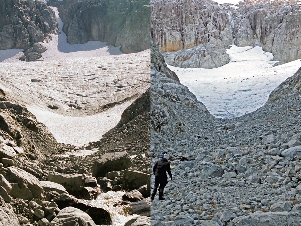
LEFT: Coquitlam Glacier in 2006. Note, the bedrock is not as exposed in this image. RIGHT: The same glacier in 2021 as it retreats and shrinks in depth due to climate change. Note how much of the bedrock exposed rock in the left-middle of the glacier. The 2021 image shows the glacier flattening (result of downwasting/melting in place) in a more "pancake-like" condition.
LEFT: Coquitlam Glacier in 2006. Note, the bedrock is not as exposed in this image. RIGHT: The same glacier in 2021 as it retreats and shrinks in depth due to climate change. Note how much of the bedrock exposed rock in the left-middle of the glacier. The 2021 image shows the glacier flattening (result of downwasting/melting in place) in a more "pancake-like" condition. PHOTO BY DAVE DUNKLEY
Article content
Metro Vancouver’s last remaining glacier is rapidly shrinking because of human-induced climate change and could disappear within three decades, says a geoscientist.
Advertisement 2
STORY CONTINUES BELOW
Article content
Dave Dunkley, a geoscientist with Metro Vancouver who has been studying the glacier for more than 15 years, said it will likely be gone by 2050, which will mean no more cool glacier water feeding into the region’s reservoirs.
“It’s always shocking to go back, and especially when I look at the 2006 photo,” he said. “As you approached the glacier, when you walked up to it, it was it was quite steep, quite high. It was a fairly intact giant ice cube.
“But now the changes are quite dramatic … there are way more crevices and more water running off in the summer. There’s a piece that’s carved up, it’s just broken right off.”
Dunkley said the Coquitlam Glacier is in a death spiral. He added that continued study of the glacier’s retreat is vital so the region can plan for more climate-change resilience, including finding another water source.
Advertisement 3
STORY CONTINUES BELOW
Article content
“The glacier is dying in front of our very eyes there,” he said. “It’s really sad. To me, it’s like losing an endangered species.”
The Coquitlam Glacier, pictured in 2006. The bedrock is not as exposed in the left-middle of the glacier.
The Coquitlam Glacier, pictured in 2006. The bedrock is not as exposed in the left-middle of the glacier. PHOTO BY DAVE DUNKLEY
The Coquitlam Glacier, pictured in 2021.
The Coquitlam Glacier, pictured in 2021. PHOTO BY DAVE DUNKLEY
By point of comparison, in 2008 Dunkley estimated the glacier would be gone within 100 years.
Without the glacier, snowpacks will melt earlier and, with more intense heat waves, water consumption will go up in the region. Dunkley said they need to plan now for more water conservation.
“We have switched to outdoor watering twice a week to once a week in the summer, but in the future it wouldn’t surprise me if there was no outdoor watering in the summer.”
Dunkley said he really noticed changes to the Coquitlam Glacier after the drought in 2015. That summer was one of the province’s worst droughts on record. An early heat wave and hot, dry conditions led to severe water rationing measure over much of the southern part of B.C.
Advertisement 4
STORY CONTINUES BELOW
Article content
“That level of drought, that was something we imagined in 2050, not 2015,” he said.
Metro Vancouver’s last remaining glacier, the Coquitlam Glacier, is shrinking because of human-induced climate change.
Metro Vancouver’s last remaining glacier, the Coquitlam Glacier, is shrinking because of human-induced climate change. PHOTO BY METRO VANCOUVER /PNG
Heat waves, like B.C.’s deadly heat dome last June, will accelerate the melt of already fragile glaciers, say experts. Dozens of temperature records were shattered during the heat dome, including a Canadian record of 49.6 C in Lytton.
Climate scientists, who have linked the heat dome to the human-induced climate crisis, say the warming planet will lead to more intense and frequent disasters such as heat waves, drought, floods and wildfires.
Brian Menounos, the Canada research chair in glacier change at the University of Northern British Columbia, said that during the heat wave the temperature was six degrees above average even at elevations of 3,000 metres.
Advertisement 5
STORY CONTINUES BELOW
Article content
Menounos said Thursday that last year was a record in terms of mass loss for some of B.C.’s glaciers, particularly those in the southern part of the province like in Garibaldi Park and the Comox Glacier on Vancouver Island.
Garibaldi’s Lava Glacier, for example, had a dramatic loss of three metres in most areas and up six metres in some parts after the heat dome, he said.
The Comox Glacier will disappear by mid century, Menounos estimated.
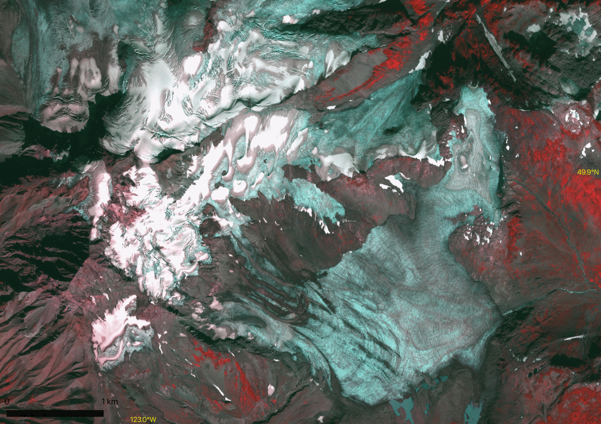
Source: Etienne Berthier (Legos) and the Pleiades Glacier Observatory. And the Hakai Institute for the LIDAR equipment. Images show how much the elevation changed after the heat dome to one of the glaciers at Garibaldi Park.
Source: Etienne Berthier (Legos) and the Pleiades Glacier Observatory. And the Hakai Institute for the LIDAR equipment. Images show how much the elevation changed after the heat dome to one of the glaciers at Garibaldi Park.
In addition to the heat dome, B.C. also had a devastating wildfire season. He said ash and smoke darkened the surface of some glaciers, causing them to absorb more energy from the sun.
“It was a really bad year for glaciers,” he said, adding that B.C.’s smaller glaciers will continue to melt until they disappear.
Advertisement 6
STORY CONTINUES BELOW
Article content
“It is sad. Even if society stopped emitting greenhouse gases we would find that glaciers would continue to lose mass simply because they’re out of equilibrium with climate,” he said.
Still, he added there is hope for some of B.C.’s larger glaciers in the north if the world can put the brakes on greenhouse-gas emissions and limit warming to 1.5 C.
“We have to recognize that these glaciers are really important freshwater resources, and we need to find collective and innovative ways to continue the monitoring going forward,” said Menounos.
— with a file from The Canadian Press
ticrawford@postmedia.com
twitter.com/tiffycrawford13


 torontosun.com
Coquitlam Glacier, shrinking due to climate change, will likely vanish by 2050, says Metro Vancouver geoscientist Dave Dunkley
Author of the article:Tiffany Crawford
Publishing date:Apr 10, 2022 • 19 hours ago • 3 minute read • Join the conversation
LEFT: Coquitlam Glacier in 2006. Note, the bedrock is not as exposed in this image. RIGHT: The same glacier in 2021 as it retreats and shrinks in depth due to climate change. Note how much of the bedrock exposed rock in the left-middle of the glacier. The 2021 image shows the glacier flattening (result of downwasting/melting in place) in a more "pancake-like" condition.
LEFT: Coquitlam Glacier in 2006. Note, the bedrock is not as exposed in this image. RIGHT: The same glacier in 2021 as it retreats and shrinks in depth due to climate change. Note how much of the bedrock exposed rock in the left-middle of the glacier. The 2021 image shows the glacier flattening (result of downwasting/melting in place) in a more "pancake-like" condition. PHOTO BY DAVE DUNKLEY
Article content
Metro Vancouver’s last remaining glacier is rapidly shrinking because of human-induced climate change and could disappear within three decades, says a geoscientist.
Advertisement 2
STORY CONTINUES BELOW
Article content
Dave Dunkley, a geoscientist with Metro Vancouver who has been studying the glacier for more than 15 years, said it will likely be gone by 2050, which will mean no more cool glacier water feeding into the region’s reservoirs.
“It’s always shocking to go back, and especially when I look at the 2006 photo,” he said. “As you approached the glacier, when you walked up to it, it was it was quite steep, quite high. It was a fairly intact giant ice cube.
“But now the changes are quite dramatic … there are way more crevices and more water running off in the summer. There’s a piece that’s carved up, it’s just broken right off.”
Dunkley said the Coquitlam Glacier is in a death spiral. He added that continued study of the glacier’s retreat is vital so the region can plan for more climate-change resilience, including finding another water source.
Advertisement 3
STORY CONTINUES BELOW
Article content
“The glacier is dying in front of our very eyes there,” he said. “It’s really sad. To me, it’s like losing an endangered species.”
The Coquitlam Glacier, pictured in 2006. The bedrock is not as exposed in the left-middle of the glacier.
The Coquitlam Glacier, pictured in 2006. The bedrock is not as exposed in the left-middle of the glacier. PHOTO BY DAVE DUNKLEY
The Coquitlam Glacier, pictured in 2021.
The Coquitlam Glacier, pictured in 2021. PHOTO BY DAVE DUNKLEY
By point of comparison, in 2008 Dunkley estimated the glacier would be gone within 100 years.
Without the glacier, snowpacks will melt earlier and, with more intense heat waves, water consumption will go up in the region. Dunkley said they need to plan now for more water conservation.
“We have switched to outdoor watering twice a week to once a week in the summer, but in the future it wouldn’t surprise me if there was no outdoor watering in the summer.”
Dunkley said he really noticed changes to the Coquitlam Glacier after the drought in 2015. That summer was one of the province’s worst droughts on record. An early heat wave and hot, dry conditions led to severe water rationing measure over much of the southern part of B.C.
Advertisement 4
STORY CONTINUES BELOW
Article content
“That level of drought, that was something we imagined in 2050, not 2015,” he said.
Metro Vancouver’s last remaining glacier, the Coquitlam Glacier, is shrinking because of human-induced climate change.
Metro Vancouver’s last remaining glacier, the Coquitlam Glacier, is shrinking because of human-induced climate change. PHOTO BY METRO VANCOUVER /PNG
Heat waves, like B.C.’s deadly heat dome last June, will accelerate the melt of already fragile glaciers, say experts. Dozens of temperature records were shattered during the heat dome, including a Canadian record of 49.6 C in Lytton.
Climate scientists, who have linked the heat dome to the human-induced climate crisis, say the warming planet will lead to more intense and frequent disasters such as heat waves, drought, floods and wildfires.
Brian Menounos, the Canada research chair in glacier change at the University of Northern British Columbia, said that during the heat wave the temperature was six degrees above average even at elevations of 3,000 metres.
Advertisement 5
STORY CONTINUES BELOW
Article content
Menounos said Thursday that last year was a record in terms of mass loss for some of B.C.’s glaciers, particularly those in the southern part of the province like in Garibaldi Park and the Comox Glacier on Vancouver Island.
Garibaldi’s Lava Glacier, for example, had a dramatic loss of three metres in most areas and up six metres in some parts after the heat dome, he said.
The Comox Glacier will disappear by mid century, Menounos estimated.
Source: Etienne Berthier (Legos) and the Pleiades Glacier Observatory. And the Hakai Institute for the LIDAR equipment. Images show how much the elevation changed after the heat dome to one of the glaciers at Garibaldi Park.
Source: Etienne Berthier (Legos) and the Pleiades Glacier Observatory. And the Hakai Institute for the LIDAR equipment. Images show how much the elevation changed after the heat dome to one of the glaciers at Garibaldi Park.
In addition to the heat dome, B.C. also had a devastating wildfire season. He said ash and smoke darkened the surface of some glaciers, causing them to absorb more energy from the sun.
“It was a really bad year for glaciers,” he said, adding that B.C.’s smaller glaciers will continue to melt until they disappear.
Advertisement 6
STORY CONTINUES BELOW
Article content
“It is sad. Even if society stopped emitting greenhouse gases we would find that glaciers would continue to lose mass simply because they’re out of equilibrium with climate,” he said.
Still, he added there is hope for some of B.C.’s larger glaciers in the north if the world can put the brakes on greenhouse-gas emissions and limit warming to 1.5 C.
“We have to recognize that these glaciers are really important freshwater resources, and we need to find collective and innovative ways to continue the monitoring going forward,” said Menounos.
— with a file from The Canadian Press
ticrawford@postmedia.com
twitter.com/tiffycrawford13
Metro Vancouver’s last remaining glacier ‘dying in front of our very eyes’
Coquitlam Glacier, shrinking due to climate change, will likely vanish by 2050, says Metro Vancouver geoscientist Dave Dunkley.