Sorry, I just assumed it was obvious. About 12,000 years ago before the current interglacial. Some of the water currently in the oceans was tied up in large masses of ice on the continents and thus the lowered sea level being approximately 400 feet lower than it is currently & thus fat Florida and the continent size landmass in the Bering Sea and what is currently Indonesia was once a large landmass etc....Today’s climate being much warmer has increased the Sea level creating the Bering Sea and the Svelte Florida that we know today, etc...
I guess I just assumed that anybody interested in the subject would recognize what they were saying so I apologize. This actually backed up your postulation about rising sea levels with warmer climate comparing modern day to the sea level during the last Ice Age.
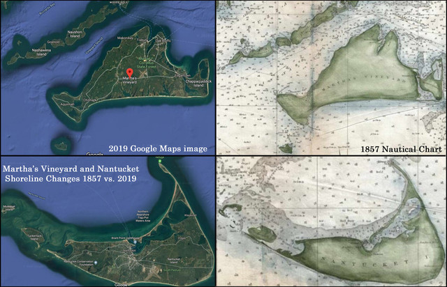
The Google earth images of Nantucket compared against the earlier mapping from approximately 150 years ago conflict with the current premise that the ocean levels are rising. With that in mind there must be something else at play. What that is is interesting all by itself because it could be that the climate is cooler now than it was 150 years ago with more water tied up as ice on the land masses lowering the sea level (?) or it could be an example fluctuating elevations of the land masses (subduction & its opposite?) or it could be showing something else altogether different and I was inquiring as to your link of data and whether or not you could explain what we were seeing? I guess I made a similar error to Frank Drake with his golden disc pictograph that nobody course understand until he explained it, making it obvious to almost all. My bad.
What do you think is happening above with Nantucket if the climate is warming and sea level is rising? Your best guess is as good as anyone else’s. Please forgive the run together paragraphs as I’m using text to talk on my phone at this point. I’ll try to fix that but I can barely see the writing on a small screen like this.


