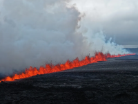
Mount Etna

bob the dog

Council Member
Aug 14, 2020
1,725
1,236
113
Maybe related to the glacier collapse in Switzerland.

 
  • Like
Reactions: Ron in Regina

petros

The Central Scrutinizer
Nov 21, 2008
116,719
14,129
113
Low Earth Orbit
Maybe related to the glacier collapse in Switzerland.


An oarfish washed up on the western shores of Tasmania today June 3rd 2025 just as geophysical disturbances were observed in the Ionosphere and background Schumann resonances (Earth's natural resonance). Did something occur that was meant to be hidden? We explore the history of nuclear tests and how they affect the geophysics of the planet. Special investigative report by geophysicist Stefan Burns.

Research:
1959 - On artificial geomagnetic and ionospheric storms associated with high-altitude explosions https://doi.org/10.102...
1961 - A note on the cause of sudden ionization anomalies in regions remote from high-altitude nuclear bursts https://doi.org/10.102...
1962 - Effects of Nuclear Explosions on the Ionosphere https://doi.org/10.103...
1963 - Ionospheric effects of a high altitude nuclear explosion https://doi.org/10.101...
2009 - Ionospheric Detection of Explosive Events https://doi.org/10.102...

00:00 Revealing the Secret Past of Nuclear Testing and the Geophysical Effects on Earth
42:33 Earth Healing Prayer (ad free)

Data:
NOAA (Real Time Solar Wind): https://www.swpc.noaa....
NOAA (GloTEC): https://www.swpc.noaa....
Space Observing System sosrff.tsu.ru
VLF Open Lab vlf.it
Hungarian Research Network https://nckobs.hu/data...
USGS The Great Alaska Earthquake 1964: https://www.usgs.gov/c...
Google Earth
Oarfish Found: https://www.abc.net.au...
Tsar Bomba: • Tsar Bomba Declassifie...
Starfish Prime: • Operation Dominic — St...

#schumannresonance #geophysics #earth #science #geology #evolution #higherconsciousness #spirituality #ascension #spaceweather
 

pgs

Hall of Fame Member
Nov 29, 2008
28,454
8,068
113
B.C.
All from recent geomagnetic storms.

Yellowstone, The Axial Seamount off Oregon - BC, Wells Grey and Garibaldi Belt are all bubbling.
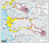
Mount Baker is about due to blow it’s top .
 

pgs

Hall of Fame Member
Nov 29, 2008
28,454
8,068
113
B.C.
Luckily Baker has been quiet. If it did the lahar would be insane. That's not a small glacier.
It blows every 350 or so years and we are in that time frame . I heard and felt Mt. St.Helen blow in 1980 and flew over it a week later so much devastation. If that happens to Baker look out Sumas .
 

petros

The Central Scrutinizer
Nov 21, 2008
116,719
14,129
113
Low Earth Orbit
It blows every 350 or so years and we are in that time frame . I heard and felt Mt. St.Helen blow in 1980 and flew over it a week later so much devastation. If that happens to Baker look out Sumas .
Far more than Sumas. If an explosive eruption like St Helen's kiss everything From Maple Ditch to Everett good bye.

The lahar covers these valleys.

1749140307592.png
 

spaminator

Hall of Fame Member
Oct 26, 2009
38,615
3,498
113
Guatemala’s Volcano of Fire erupts again, spurring new evacuations
Author of the article:Associated Press
Associated Press
Published Jun 05, 2025 • 1 minute read

Volcano of Fire
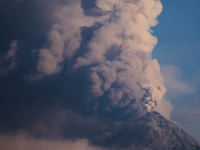
The "Volcan de Fuego," or Volcano of Fire, blows a thick cloud of ash, seen from Palin, Guatemala, Monday, March 10, 2025. Photo by Moises Castillo /AP Photo
GUATEMALA CITY — Guatemala began evacuating some residents from the slopes the Volcano of Fire Thursday after a new eruption spewed hot gas and ash high into the sky.


Juan Laureano, spokesperson for the National Disaster Reduction Co-ordinator, said that at least 594 people were moved to shelters from five communities in the Chimaltenango, Escuintla and Sacatepequez departments.


Laureano said that given the volcano’s activity, the number of evacuees was expected to rise.


Wilver Guerra, a 28-year-old resident of El Porvenir, moved to a shelter in Chimaltenango.

“At first, everything was normal, only fire in the morning when the volcano’s activity increased a bit, but it’s OK, better to evacuate in time,” he said.

Authorities also closed a highway in the area and suspended classes at 39 schools.

The 3,763-m volcano is one of the most active in Central America. It is 53 km from Guatemala’s capital.

A 2018 eruption killed 194 people and left another 234 missing.
1749301479831.png
 

Ron in Regina

"Voice of the West" Party
Apr 9, 2008
28,701
10,830
113
Regina, Saskatchewan
Pulled this up on the big screen so I can listen to it through the background as it’s 40+ minutes long…
1749316509740.jpeg
But stumbled across this in the comment section, & just love it!! Awesome!!
1749316561723.jpeg
 
  • Like
Reactions: petros

spaminator

Hall of Fame Member
Oct 26, 2009
38,615
3,498
113
Alert raised to the highest level after Indonesia volcano erupts
An eruption of Mount Lewotobi Laki Laki in November killed nine people and injured dozens

Author of the article:Associated Press
Associated Press
Published Jun 17, 2025 • 1 minute read

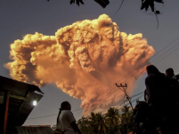
People watch as Mount Lewotobi Laki-Laki spews volcanic materials into the air during an eruption, in Maumere, Indonesia, Tuesday, June 17, 2025. (AP Photo)
People watch as Mount Lewotobi Laki-Laki spews volcanic materials into the air during an eruption, in Maumere, Indonesia, Tuesday, June 17, 2025. (AP Photo) AP
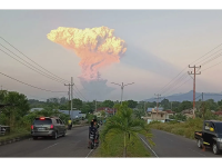
LEMBATA, Indonesia — Mount Lewotobi Laki Laki volcano in south-central Indonesia erupted on Tuesday, spewing towering columns of hot ash into the air. Authorities raised the eruption alert to the highest level and expanded the danger zone to 8 kilometers (about 5 miles) from the crater.


Indonesia’s Geology Agency said in a statement it recorded the volcano unleashing 10,000 meters (about 32,800 feet) of thick grey clouds on Tuesday afternoon, following significant volcanic activities, including 50 in two hours, rather than the usual daily 8 to 10 activities.


The ashes expanded into a mushroom-shaped ash cloud that could be seen from the cities located 90 kilometers (about 56 miles) to 150 kilometers (nearly 93 miles) from the mountain.

There were no casualties reported.

Residents were warned to be vigilant about heavy rainfall triggering lava flows in rivers originating from the volcano

An eruption of Mount Lewotobi Laki Laki in November killed nine people and injured dozens.

The 1,584-meter (5,197-foot) mountain is a twin volcano with Mount Lewotobi Perempuan in the district of Flores Timur.

Indonesia is an archipelago of 270 million people with frequent seismic activity. It has 120 active volcanoes and sits along the “Ring of Fire,” a horseshoe-shaped series of seismic fault lines encircling the Pacific Basin.
1750315872532.png
 

spaminator

Hall of Fame Member
Oct 26, 2009
38,615
3,498
113
Volcanic eruption in Indonesia forces evacuations and flight cancellations
Author of the article:Associated Press
Associated Press
Handrianus Belutowe And Edna Tarigan
Published Jun 18, 2025 • 2 minute read

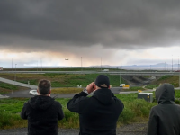
Villagers watch the eruption of Mount Lewotobi Laki-Laki as seen from Talibura village in Sikka, East Nusa Tenggara, on Tuesday, June 17, 2025.
Villagers watch the eruption of Mount Lewotobi Laki-Laki as seen from Talibura village in Sikka, East Nusa Tenggara, on Tuesday, June 17, 2025. Photo by STRINGER / AFP /Getty Images
LEMBATA, Indonesia — Indonesia’s Mount Lewotobi Laki Laki erupted with giant ash and smoke plumes again Wednesday after forcing evacuations of villages and flight cancellations, including to and from the resort island of Bali.


Several eruptions sent ash up to 5,000 metres (16,400 feet) into the sky Tuesday evening to Wednesday afternoon. An eruption Tuesday afternoon sent thick, gray clouds 10,000 metres (about 32,800 feet) into the sky that expanded into a mushroom-shaped ash cloud visible as much as 150 kilometres (nearly 93 miles) away.


The eruption alert was raised Tuesday to the highest level and the danger zone where people are recommended to leave was expanded to 8 kilometres (about 5 miles) from the crater.

Officers also evacuated from the Mount Lewotobi Laki Laki monitoring post 7 kilometres (4.3 miles) from the crater to avoid falling gravel released in the eruption. No casualties have been reported.

Ash and debris fell in a number of places outside the danger zone, including the villages of Boru, Hewa and Watobuku. Some residents from Nurabelen village in Ile Bura subdistrict fled to evacuation sites in Konga to avoid the impact of the eruption, the National Disaster Management Agency said in a statement.


“Some residents have also evacuated to Nileknoheng village, which is 12 kilometres (7.4 miles) from the crater,” said Abdul Muhari, the National Disaster Management Agency’s spokesperson.

Dozens of flights Wednesday were cancelled, including those connecting Bali to cities in Australia, Malaysia, India and China, according to the website of Bali’s I Gusti Ngurah Rai International Airport. Volcanic ash can pose a risk to plane engines.

Flights also were cancelled to and from the international airport in Labuan Bajo another tourist destination in Flores Island, East Nusa Tenggara province. The airport is still operating.

The cancellations and delays affected thousands of travelers. Australian carrier Jetstar, which flies daily between the tourist hotspot and several Australian cities, said the ash cloud was forecast to clear by late Wednesday and its services would be rescheduled.


Air New Zealand cancelled one return trip to Auckland and would rebook customers on the next available service, the airline said in a statement Wednesday. Flights to New Delhi, Singapore and Pudong, China, were also cancelled due to the volcano, according to information on the website for Denpasar airport in Bali.

The 1,584-metre (5,197-foot) Mount Lewotobi Laki Laki is a twin volcano with Mount Lewotobi Perempuan in the district of Flores Timur.

The volcano has had several eruptions, and its danger level and no-go zone have changed several times before being raised again to the highest level Tuesday.

An eruption of Mount Lewotobi Laki Laki in November killed nine people and injured dozens. It also erupted in March.

Indonesia is an archipelago of 270 million people with frequent seismic activity. It has 120 active volcanoes and sits along the “Ring of Fire,” a horseshoe-shaped series of seismic fault lines encircling the Pacific Basin.

— Tarigan reported from Jakarta, Indonesia.
1750357180120.png