Florida flooding emergency declared as tropical threat draws near
Author of the article:Associated Press
Associated Press
Kate Payne
Published Aug 02, 2024 • Last updated 20 hours ago • 3 minute read
TALLAHASSEE, Fla. — A storm system brewing over Cuba on Friday will likely dump torrential rains over the Florida peninsula this weekend, a forecast that’s especially concerning for low-lying coastal and urban areas that were inundated by dangerous floods this year.
The National Hurricane Center in Miami said there’s a 90% chance it will strengthen into a tropical storm by Saturday night as it curves northward just off the southwest Florida coast, where the water has been extremely warm, with temperatures approaching 92 degrees Fahrenheit (33 Celsius) this week.
The hurricane center has labeled it Potential Tropical Cyclone Four for now. The next name on this season’s list is Debby. “Regardless of development, heavy rains could cause areas of flash flooding across Florida, Cuba, and the Bahamas through the weekend,” its advisory said.
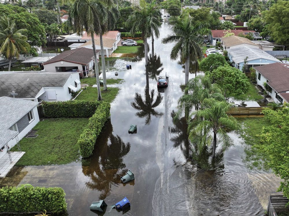
It doesn’t take a name for flooding to become dangerous. Torrential rains from a tropical disturbance in June left many Florida roads impassable, swamping school buses and stranding residents as cars floated away down flooded streets.
“Hurricanes aren’t the only problem, right?” said Tom Frazer, Executive Director of the Florida Flood Hub for Applied Research and Innovation at the University of South Florida.
“We can have very rapidly developing storm systems that take advantage of extremely warm sea waters and high water content in the atmosphere to deposit large amounts of rain on various parts of the peninsula,” Frazer said.
Forecasting models predict it could come ashore as a tropical storm on Sunday and cross over Florida’s Big Bend region into the Atlantic Ocean, where it’s likely to remain a tropical storm threatening Georgia and the Carolinas early next week.
At a county park in Plant City east of Tampa, there was a steady stream of people shoveling sand into bags Friday morning. Terry Smith, 67, filled 10 bags with a neighbor from StrawBerry Ridge Village, a 55+ community of manufactured homes in suburban Hillsborough County.
Smith said he isn’t overly concerned about the storm, though he doesn’t have home insurance.
“Life is a risk,” Smith said. “We’re just probably going to try and stay in Saturday and Sunday and ride it out.”
In Fort Lauderdale, the flooding in June was so bad that the city has kept open sites where residents can fill up to five sandbags a day until further notice.
“The most significant impact from this storm will be the rainfall. Hefty totals are forecast over the next five days, with the bulk coming Saturday-Monday in Florida,” University of Miami meteorologist Brian McNoldy noted on X.
Florida Gov. Ron DeSantis declared a state of emergency for most Florida counties, extending from the Florida Keys up through Central Florida and the Tampa Bay region and into the western Panhandle.
DeSantis spoke of sea level rise and the threat it poses to Florida during his first term as governor, but that message quieted after he won re-election and ran for president. Despite record heat and increasingly costly hurricanes, DeSantis recently signed legislation that erases most references to climate change in state law and nullifies goals of transitioning the state towards cleaner energy.
Meanwhile, far off Mexico’s western coast, Hurricane Carlotta formed over the Pacific Ocean on Friday, with top sustained winds reaching 80 mph (130 kmh). The hurricane center said Carlotta was moving west-northwest about 455 miles (730 kilometers) southwest of the southern tip of the Baja California peninsula, and no watches or warnings were in effect.

 torontosun.com
Author of the article:Associated Press
Associated Press
Kate Payne
Published Aug 02, 2024 • Last updated 20 hours ago • 3 minute read
TALLAHASSEE, Fla. — A storm system brewing over Cuba on Friday will likely dump torrential rains over the Florida peninsula this weekend, a forecast that’s especially concerning for low-lying coastal and urban areas that were inundated by dangerous floods this year.
The National Hurricane Center in Miami said there’s a 90% chance it will strengthen into a tropical storm by Saturday night as it curves northward just off the southwest Florida coast, where the water has been extremely warm, with temperatures approaching 92 degrees Fahrenheit (33 Celsius) this week.
The hurricane center has labeled it Potential Tropical Cyclone Four for now. The next name on this season’s list is Debby. “Regardless of development, heavy rains could cause areas of flash flooding across Florida, Cuba, and the Bahamas through the weekend,” its advisory said.
It doesn’t take a name for flooding to become dangerous. Torrential rains from a tropical disturbance in June left many Florida roads impassable, swamping school buses and stranding residents as cars floated away down flooded streets.
“Hurricanes aren’t the only problem, right?” said Tom Frazer, Executive Director of the Florida Flood Hub for Applied Research and Innovation at the University of South Florida.
“We can have very rapidly developing storm systems that take advantage of extremely warm sea waters and high water content in the atmosphere to deposit large amounts of rain on various parts of the peninsula,” Frazer said.
Forecasting models predict it could come ashore as a tropical storm on Sunday and cross over Florida’s Big Bend region into the Atlantic Ocean, where it’s likely to remain a tropical storm threatening Georgia and the Carolinas early next week.
At a county park in Plant City east of Tampa, there was a steady stream of people shoveling sand into bags Friday morning. Terry Smith, 67, filled 10 bags with a neighbor from StrawBerry Ridge Village, a 55+ community of manufactured homes in suburban Hillsborough County.
Smith said he isn’t overly concerned about the storm, though he doesn’t have home insurance.
“Life is a risk,” Smith said. “We’re just probably going to try and stay in Saturday and Sunday and ride it out.”
In Fort Lauderdale, the flooding in June was so bad that the city has kept open sites where residents can fill up to five sandbags a day until further notice.
“The most significant impact from this storm will be the rainfall. Hefty totals are forecast over the next five days, with the bulk coming Saturday-Monday in Florida,” University of Miami meteorologist Brian McNoldy noted on X.
Florida Gov. Ron DeSantis declared a state of emergency for most Florida counties, extending from the Florida Keys up through Central Florida and the Tampa Bay region and into the western Panhandle.
DeSantis spoke of sea level rise and the threat it poses to Florida during his first term as governor, but that message quieted after he won re-election and ran for president. Despite record heat and increasingly costly hurricanes, DeSantis recently signed legislation that erases most references to climate change in state law and nullifies goals of transitioning the state towards cleaner energy.
Meanwhile, far off Mexico’s western coast, Hurricane Carlotta formed over the Pacific Ocean on Friday, with top sustained winds reaching 80 mph (130 kmh). The hurricane center said Carlotta was moving west-northwest about 455 miles (730 kilometers) southwest of the southern tip of the Baja California peninsula, and no watches or warnings were in effect.

Florida flooding emergency declared as tropical threat draws near
A storm system brewing over Cuba on Friday will likely dump torrential rains over the Florida peninsula this weekend


