St Jude's Storm set to leave trail of destruction across Britain
- Thread starter Locutus
- Start date
You are using an out of date browser. It may not display this or other websites correctly.
You should upgrade or use an alternative browser.
You should upgrade or use an alternative browser.
Re: Enjoy next week Blackleaf
8O.............Head for high ground, Blackleaf. We're rootin fer ya.
8O.............Head for high ground, Blackleaf. We're rootin fer ya.
The worst storm to hit Britain for 26 years is set to hit landfall in south western England tonight.
St Jude's Storm is predicted to be the strongest storm to hit Britain since the infamous Great Storm of 15/16 October 1987, which killed 22 people and caused widespread damage throughout Britain and France.
St Jude's Storm is expected to leave a trail of destruction across a large swathe of the UK, bringing down trees and causing widespread structural damage, leading to power cuts and transport chaos tomorrow morning.
Surface water floods could strike much of England as the Met Office predicts 20-40mm of rain could fall within six to nine hours overnight.
The Prime Minister held an emergency meeting this morning with ministries and agencies to co-ordinate plans to protect public from tonight's storm.
A vast area of low pressure is forming over the Atlantic Ocean and ‘Storm St Jude’ – named after the patron saint of lost causes, whose feast day is tomorrow – is expected to hit the South-West coast at around midnight before causing havoc across the South.
Atlantic storms of this type usually develop further west across the ocean, losing strength by the time they reach the UK and Ireland.
But this is expected to appear much closer to land, potentially moving across the country while in its most powerful phase.
The Met Office said it was increasingly confident that the ferocious weather would cut a swathe from Wales to the Humber, bringing down trees and causing structural damage, though officials were still not sure of the exact course of the storm.
It has issued an amber warning, meaning 'be prepared', for the southern half of England and the southern half of Wales.
It gave a lesser yellow warning, meaning 'be aware', for the rest of Wales and England up to the border with Scotland.
Some experts are predicted that St Jude's could be even stronger than the Great Storm of 1987.
Brace yourself: St Jude's Storm with 90mph winds and heavy rain WILL hit Britain tonight wreaking havoc across country as coastguard launch desperate hunt for photographer washed off sea wall in high seas
Furious storm will also bring heavy rain with it with potential for floods
Forecasters warn houses face damage, trees falling and power cuts
Insurers tell householders they must protect their homes
Wales and South West England will be hit first early on Monday morning
In some coastal areas in the south winds could reach gusts of up to 90mph
When storm hits drivers are warned against all but essential travel
Firefighters have issued a safety warning to Londoners
Police have warned people to only dial 999 in a genuine emergency
Prime Minister has held a meeting to co-ordinate plans to protect public from tonight's storm
By Jonathan Petre
26 October 2013
Daily Mail
Daily Mail

St Jude's Storm could be even stronger than the Great Storm of October 1987, which left a trail of destruction across the UK and 22 people deadhttp://forums.canadiancontent.net/n...apher-washed-sea-wall-high-seas.html#comments
Britain is braced for the worst storm for 26 years tonight which is set to bring driving rain and winds of up to 90mph to some areas.
The winds are expected to leave a trail of destruction across a large swathe of the UK, bringing down trees and causing widespread structural damage, leading to power cuts and transport chaos tomorrow morning.
Surface water floods could strike much of England as the Met Office predicts 20-40mm of rain could fall within six to nine hours overnight.
The Prime Minister held an emergency meeting this morning with ministries and agencies to co-ordinate plans to protect public from tonight's storm

Clouds gather over Portishead on the banks of the Severn Estuary near Bristol this morning. An amber weather warning has been issued across large parts of the UK

Choppy: Waves crash into Brighton Pier as the storm begins to form out at sea

Strong waves: A train is struck by waves as it passes through Dawlish in Devon
A vast area of low pressure is forming over the Atlantic Ocean and ‘Storm St Jude’ – named after the patron saint of lost causes – is expected to hit the South-West coast at around midnight before causing havoc across the South.
Atlantic storms of this type usually develop further west across the ocean, losing strength by the time they reach the UK and Ireland.
But this is expected to appear much closer to land, potentially moving across the country while in its most powerful phase.
The Met Office said it was increasingly confident that the ferocious weather would cut a swathe from Wales to the Humber, bringing down trees and causing structural damage, though officials were still not sure of the exact course of the storm.
It has issued an amber warning, meaning 'be prepared', for the southern half of England and the southern half of Wales.
It gave a lesser yellow warning, meaning 'be aware', for the rest of Wales and England up to the border with Scotland.

Fierce waves: A man walks his dog along the beach as waves hit the seafront in Brighton this morning. Britain is bracing itself for the worst storm of the decade

The calm before the storm: Seas become increasingly rough and skies darken over Clevedon near Bristol this morning as the west country prepares itself for a battering by a storm which forecasters believe could be the worst in years

Brace yourselves: Waves crash against the marina walls in Brighton this morning. Britain will be hit by 90mph winds and heavy rain

Struggle: A woman battles with an umbrella on Butser Hill, Hampshire, as Britain braces its self for the worst storms since 1987
Search and rescue teams began looking for a photographer feared to have been washed off the Cobb wall at Lyme Regis in Dorset.
Meanwhile the hunt continues for a fisherman who is feared to have been swept away in a storm-swollen river in Berkshire.
Emergency services searched the river banks for clues to what happened to Steven Stringer, 62, from Basingstoke.
He was last seen fishing on the River Kennet at Theale, three miles upstream from where it flows into the Thames at Reading.
The hunt began on Saturday as the river levels continued to rise with more and more heavy rain falling.
The last definite sighting of him was at 5pm on Friday by someone who saw him fishing where the Kennet flows close to Wigmore Lane in Theale.
With gales lashing the area, fire crews including a water rescue unit and control vehicle from Caversham Road were joined by Thames Valley Police divers.

Waves pound against Brighton Beach's sea defences this morning as the UK prepares for one of the worst storms in a decade
As they searched along the river with police dogs, the National Police Air Service helicopter hovered overhead with a spotlight and thermal imaging equipment.
Police also carried out door-to-door enquiries along Wigmore Lane, where the swollen roiver swirls to depths of more than fifteen feet.
Police also carried out door-to-door enquiries along Wigmore Lane, where the swollen roiver swirls to depths of more than fifteen feet.
John Murby, fire brigade spokesman, said: 'There was some fishing gear that had been left unattended, and we searched up and downstream but weren't able to find the man in the river.'
Mr Stringer is 5ft 11ins tall with short white hair and a beard and was wearing his favourite fishing jacket.
Detective Inspector Laura Macinnes said: 'I would urge anyone who was in the Wigmore Lane area who may have seen Mr Stringer, or anyone with any information about Mr Stringer's whereabouts to contact Thames Valley Police immediately.'
Frank Saunders, chief forecaster at the Met Office, said last night: 'We are confident that a severe storm will affect Britain on Sunday night and Monday.
'We are now looking at refining the details about which areas will see the strongest winds and the heaviest rain.

Gloomy: Motorists on the M6 battle against the elements on the rain soaked motorway in Cumbria, as forecasters warn of a damaging storm heading for Britain

Brave: A member of Brighton Swimming Club takes his daily dip despite the weather by Brighton Pier this morning as the worst storms in 20 years have been forecast to hit later this weekend
'This is a developing situation and we'd advise people to stay up to date with our forecasts and warnings over the weekend, and be prepared to change their plans if necessary.
'We'll continue to work closely with authorities and emergency services to ensure they are aware of the expected conditions.'
Forecasters say it could still move to the North, engulfing parts of Yorkshire, or even veer to the South, sparing Britain and hitting France instead.
Huge waves could lash parts of the South Coast, more than two inches of rain could cause surface flooding, and many trees could be uprooted, damaging buildings, disrupting transport and cutting power.
The Environment Agency warned of surface flooding incidents across most of England as predictions suggest as much as an inch of rain could fall in just six hours.
The Met Office described the storm as not one 'you would see every year', and said the expected wind strengths would be similar to storms in March 2008, January 2007 and October 2000.


Insurance companies have advised householders to take steps to protect themselves and their property.
These include establishing an evacuation plan, ensuring gutters are clear and placing valuables upstairs to limit flood damage.
The Met Office added that the expected storm was ‘not one you would see every year’, and could be compared to those that took place in March 2008, January 2007 and October 2000.
Forecasters said they could not rule out declaring a ‘red alert’, meaning there was ‘a high risk of serious disruption’, and warned that the chaos could coincide with tomorrow’s morning rush-hour.


Tough conditions: Runners taking part in the Bupa Great South 5k run were up against it as the weather was windy and wet for the race

Keep going: Runners took part in the race in Portsmouth, Hampshire, ahead of the Great South Run

Making the most of it: Kitesurfers enjoy the blustery conditions at Heacham, Norfolk
The Met Office’s Helen Chivers said: ‘We believe the wind will probably be worst in coastal regions, but even inland we could see it reaching 80 miles per hour or more.’
The last time winds reached that level was in October 2002.
Atlantic storms of this type usually develop further west across the ocean, and lose strength by the time they reach the UK and Ireland.
But a strong jet stream and warm air close to the UK are contributing to St Jude’s power.

Britain is set to be hit by the worst weather since the Great Storm of 1987 when this tree crashed over in Eynsford, Kent
The Met Office said it could not give exact details of where the storm would be at its worst, but it has issued amber warnings – meaning ‘be prepared’ – for the South-West, the East of England, South Wales, the West Midlands, the East Midlands, London and the South-East.
It gave a lesser yellow warning – meaning ‘be aware’ – for the rest of Wales and England up to the border with Scotland. There are also localised flood warnings in the North of England.
The storm is expected to reach the eastern side of the country by around noon tomorrow – St Jude’s Day – and will not have cleared the coast of East Anglia until about 9pm.
Insurance companies have advised householders to take steps to protect themselves and their property.
These include establishing an evacuation plan, ensuring gutters are clear and placing valuables upstairs to limit flood damage.
The Met Office added that the expected storm was ‘not one you would see every year’, and could be compared to those that took place in March 2008, January 2007 and October 2000.
Forecasters said they could not rule out declaring a ‘red alert’, meaning there was ‘a high risk of serious disruption’, and warned that the chaos could coincide with tomorrow’s morning rush-hour.

Storm conditions : Britain could be battered by 90mph winds by what could be the worst storm since the Great Storm of 1987. This is the path it will follow and when it will hit

St Jude's Storm could be even more destructive than the Great Storm of October 1987, which killed 22 people and left a swathe of destruction across Britain
Last edited:
Probably not, no one was smiling.It's likely to do billions of pounds worth of improvements.
It's likely to do billions of pounds worth of improvements.
I thought the same when Hurricane Katrina hit.
Ya, probably, but that's most likely caused by the fact that you didn't steal that culture. Pity that eh.I thought the same when Hurricane Katrina hit.
Ya, probably, but that's most likely caused by the fact that you didn't steal that culture. Pity that eh.
What on Earth are you going on about?
The same thing you are.What on Earth are you going on about?
What on earth are you going on about?
The same thing you are.
What on earth are you going on about?
I was saying that I thought Hurricane Katrina caused billions of pounds worth of improvements.
I was saying that I thought Hurricane Katrina caused billions of pounds worth of improvements.
It certainly did. And exposed some serious deficiencies in ACE flood control measures.
It certainly did. And exposed some serious deficiencies in ACE flood control measures.
Typical Yanks. Can't build anything that lasts.
Ya, that's likely because you couldn't steal that culture.I was saying that I thought Hurricane Katrina caused billions of pounds worth of improvements.
Like the Briddish Empire?Typical Yanks. Can't build anything that lasts.
Speaking of things that don't last, how's the Empire?Typical Yanks. Can't build anything that lasts.
Oh, that's right. It's a client state of the U.S. and the EU.
Here comes St Jude! She's getting nearer....
Here it comes! South coast is lashed by 25ft waves ahead of St Jude's storm as train companies announce NO services before 9am tomorrow
Amendments and cancellations on First Capital Connect, Southeastern, Greater Anglia and Stansted Express
Also disruption on East Coast, c2c, First Great Western, Southern, Gatwick Express and South West Trains
Forecasters warn houses face damage, trees falling and power cuts
Wales and South West England will be hit first early tomorrow morning with winds of up to 90mph expected
Boy, 14, believed to have drowned today after swimming with friends in waves off Newhaven in East Sussex
Canoeist dies after being pulled from swollen River Tees near Barnard Castle, County Durham, after capsizing
By Tara Brady, Mark Duell and Jonathan Petre
26 October 2013
Daily Mail
The biggest storm to hit Britain for 26 years is set to cause travel chaos tomorrow morning as rail operators cancel services and airports ground flights.
Many train companies in southern England have announced they will be running amended timetables, with some not operating at all until late morning.
Network Rail told passengers to allow extra time to reach stations and to catch connecting trains, with road conditions also expected to be hazardous.
First Capital Connect is not expecting to run until 9am while Southeastern will run an amended timetable with services potentially not starting until 10am.
There will be no Greater Anglia or Stansted Express services until after 9am, when there will be a reduced service with significant disruption expected.
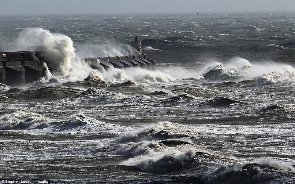
Wild: Rough seas pound the sea wall of Brighton Marina today as the south coast braced itself for the storm to hit

Caught without an umbrella: A family runs for cover as torrential rain in Appledore, Devon, marks the start of the storm

A kite surfer enjoys the stormy seas at Fistral Beach, in Newquay, Cornwall today ahead of the storm which will hit tonight

A helicopter was called out to search for a photographer feared to have been swept out to sea when he was taking photographs on a Cobb wall in Lyme Regis in Dorset

Portleven in Cornwall braces itself for high winds and rain this morning when the storm reaches its peak tonight
 Warning signs: Traffic signs warning of strong winds on the A5 motorway, Staffordshire, as England and Wales face a battering tonight

Blocked off: Winds start to batter the Sussex coastline as a tree falls in Brighton

Destroyed: This wind turbine couldn't cope with the wind in a field near Teignmouth, Devon

The Prime Minister held an emergency meeting this morning with ministers and agencies to co-ordinate plans to protect public from tonight's storm
East Coast is operating an extreme weather timetable and c2c is expected to run an amended timetable with trains running at reduced speeds.
First Great Western, Southern and Gatwick Express said they may run an amended service. South West Trains said it expected an amended timetable.
Eight flights between Ireland and London Heathrow have been cancelled. Aer Lingus services between Dublin, Cork, Belfast and Heathrow were affected.
The winds are expected to leave a trail of destruction across a large swathe of the UK, bringing down trees and causing widespread structural damage.
Surface water floods could strike much of England as the Met Office predicts 0.8 to 1.6in of rain could fall within six to nine hours overnight.
Meanwhile, a 14-year-old boy was believed to have drowned after swimming with friends off Newhaven in East Sussex.

People gather to watch the rough seas in Cornwall this morning. Winds are expected to leave a trail of destruction tonight

Bad hair day: A girl's long hair gets swept up in the wind as she walks along Brighton Beach this afternoon
The friends are safe, but an immediate search was launched involving police, coastguards and the in-shore lifeboat.
A Sussex Police spokesman said: 'This is a very distressing incident and everything possible is being done to try to find the boy.'
The Prime Minister held an emergency meeting this morning with ministries and agencies to co-ordinate plans to protect the public from tonight's storm.
Robin Gisby, Network Rail’s managing director of network operations, said: 'We are monitoring the forecast closely and have put in place agreed industry plans for dealing with difficult conditions such as these.
'Our maintenance teams will be out over the weekend to check that key drainage points are clear and we will have additional teams available across the network to clear fallen trees and repair any damaged equipment as quickly as possible to allow train operators to keep services running safely. As ever, safety is our top priority.'

A wind turbine collapsed in strong winds which hit Devon on Saturday night.
No-one was injured when the 89ft high turbine crashed down into a field at a farm in the hamlet of Luton near Teignmouth, Devon.
Firefighters in Ilfracombe, North Devon, dismantled a small wind turbine from the roof of a house in the seaside town after a report saying it was in a 'precarious position'.
Read more: UK weather: South coast is lashed by 25ft waves ahead of St Jude's storm | Mail Online
Follow us: @MailOnline on Twitter | DailyMail on Facebook
We'll be out of the EU within ten years.
We're nobody's client state.
Here it comes! South coast is lashed by 25ft waves ahead of St Jude's storm as train companies announce NO services before 9am tomorrow
Amendments and cancellations on First Capital Connect, Southeastern, Greater Anglia and Stansted Express
Also disruption on East Coast, c2c, First Great Western, Southern, Gatwick Express and South West Trains
Forecasters warn houses face damage, trees falling and power cuts
Wales and South West England will be hit first early tomorrow morning with winds of up to 90mph expected
Boy, 14, believed to have drowned today after swimming with friends in waves off Newhaven in East Sussex
Canoeist dies after being pulled from swollen River Tees near Barnard Castle, County Durham, after capsizing
By Tara Brady, Mark Duell and Jonathan Petre
26 October 2013
Daily Mail
The biggest storm to hit Britain for 26 years is set to cause travel chaos tomorrow morning as rail operators cancel services and airports ground flights.
Many train companies in southern England have announced they will be running amended timetables, with some not operating at all until late morning.
Network Rail told passengers to allow extra time to reach stations and to catch connecting trains, with road conditions also expected to be hazardous.
First Capital Connect is not expecting to run until 9am while Southeastern will run an amended timetable with services potentially not starting until 10am.
There will be no Greater Anglia or Stansted Express services until after 9am, when there will be a reduced service with significant disruption expected.
Wild: Rough seas pound the sea wall of Brighton Marina today as the south coast braced itself for the storm to hit
Caught without an umbrella: A family runs for cover as torrential rain in Appledore, Devon, marks the start of the storm
A kite surfer enjoys the stormy seas at Fistral Beach, in Newquay, Cornwall today ahead of the storm which will hit tonight
A helicopter was called out to search for a photographer feared to have been swept out to sea when he was taking photographs on a Cobb wall in Lyme Regis in Dorset
Portleven in Cornwall braces itself for high winds and rain this morning when the storm reaches its peak tonight
Blocked off: Winds start to batter the Sussex coastline as a tree falls in Brighton
Destroyed: This wind turbine couldn't cope with the wind in a field near Teignmouth, Devon
The Prime Minister held an emergency meeting this morning with ministers and agencies to co-ordinate plans to protect public from tonight's storm
East Coast is operating an extreme weather timetable and c2c is expected to run an amended timetable with trains running at reduced speeds.
First Great Western, Southern and Gatwick Express said they may run an amended service. South West Trains said it expected an amended timetable.
Eight flights between Ireland and London Heathrow have been cancelled. Aer Lingus services between Dublin, Cork, Belfast and Heathrow were affected.
The winds are expected to leave a trail of destruction across a large swathe of the UK, bringing down trees and causing widespread structural damage.
Surface water floods could strike much of England as the Met Office predicts 0.8 to 1.6in of rain could fall within six to nine hours overnight.
Meanwhile, a 14-year-old boy was believed to have drowned after swimming with friends off Newhaven in East Sussex.
People gather to watch the rough seas in Cornwall this morning. Winds are expected to leave a trail of destruction tonight
Bad hair day: A girl's long hair gets swept up in the wind as she walks along Brighton Beach this afternoon
The friends are safe, but an immediate search was launched involving police, coastguards and the in-shore lifeboat.
A Sussex Police spokesman said: 'This is a very distressing incident and everything possible is being done to try to find the boy.'
The Prime Minister held an emergency meeting this morning with ministries and agencies to co-ordinate plans to protect the public from tonight's storm.
Robin Gisby, Network Rail’s managing director of network operations, said: 'We are monitoring the forecast closely and have put in place agreed industry plans for dealing with difficult conditions such as these.
'Our maintenance teams will be out over the weekend to check that key drainage points are clear and we will have additional teams available across the network to clear fallen trees and repair any damaged equipment as quickly as possible to allow train operators to keep services running safely. As ever, safety is our top priority.'
A wind turbine collapsed in strong winds which hit Devon on Saturday night.
No-one was injured when the 89ft high turbine crashed down into a field at a farm in the hamlet of Luton near Teignmouth, Devon.
Firefighters in Ilfracombe, North Devon, dismantled a small wind turbine from the roof of a house in the seaside town after a report saying it was in a 'precarious position'.
Read more: UK weather: South coast is lashed by 25ft waves ahead of St Jude's storm | Mail Online
Follow us: @MailOnline on Twitter | DailyMail on Facebook
Oh, that's right. It's a client state of the U.S. and the EU.
We'll be out of the EU within ten years.
We're nobody's client state.
Last edited:
You'll never be out of the EU, and your attempt to pretend you are not wholly the slave of Brussels by clinging to sterling is pathetic. It fools no-one.We'll be out of the EU within ten years.
We're nobody's client state.
And on the rare issue where you are not a slave to Brussels, you are a wh0re to Washington. We whistle, and you send some tiny mob of what's left of your army and navy to lick our hands and do as you're told.
You'll never be out of the EU, and your attempt to pretend you are not wholly the slave of Brussels by clinging to sterling is pathetic. It fools no-one.
And on the rare issue where you are not a slave to Brussels, you are a wh0re to Washington. We whistle, and you send some tiny mob of what's left of your army and navy to lick our hands and do as you're told.
Washington, hahahahahahahahahahahhhhahhahhahahhahahahahahah the provincial capital of an Israeli colony.
T
ypo
see
above &
graph
:
warm / m
ild
This is
http://www.wea
theraction.com/docs/WANews13No44
issued 2
6 Oct 2013
The BIG ONE
*
Storm
Special news
–
Blog
*
bit.ly/19rwAPN
*
N
amed
“
The Piers Corbyn storm of 2013
”
by WeatherAction forecast users
!
Forecasts & further discussion
www.W
eatherAction.com
and Latest / Comments
+442079399946 / +447908734296
“The damage from this
storm
–
which
we
predicted to within a
day
6 weeks
ahead
-
will be
on a par with
the Great Storm of Oct
15/16
t
h
1987
”
-
says
Piers Corbyn
astrophysicist and chief forecaster
WeatherAction Long range
Weather and Climate
forecasters
, 26 Oct 2013.
Forecast issued 17 Sept
,
Right
-
Piers
advises
this
along with further special
information
including
possible
modifications
needed to
the
MetOffice
storm track forecast
in a special note to WeatherAction
subscribers to
WeatherAction
Britain+
Ireland And
Euro
forecast services
–
only
available to subscribers
.
Wea
19Oct+ongo Damaging wild October - and beyond - weather; Traflgar Night storms (208th anniv) Europe & USA (snow)! NEW WeatherAction TV trashes UN Climate Report; AND MORE
WeatherAction long range warnings of extreme events Brit+Ire, Europe and USA in later parts of October are being confirmed. These are a consequence of the developing Wild Jet Stream / Mini Ice Age we warned about years ago due to low solar activity. CO2 warmism is clueless on these events
You'll never be out of the EU .
Yes, we will. We'll vote to leave the EU in the EU in/out referendum in 2017.