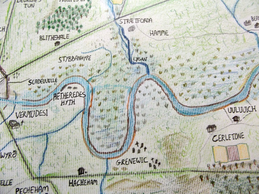
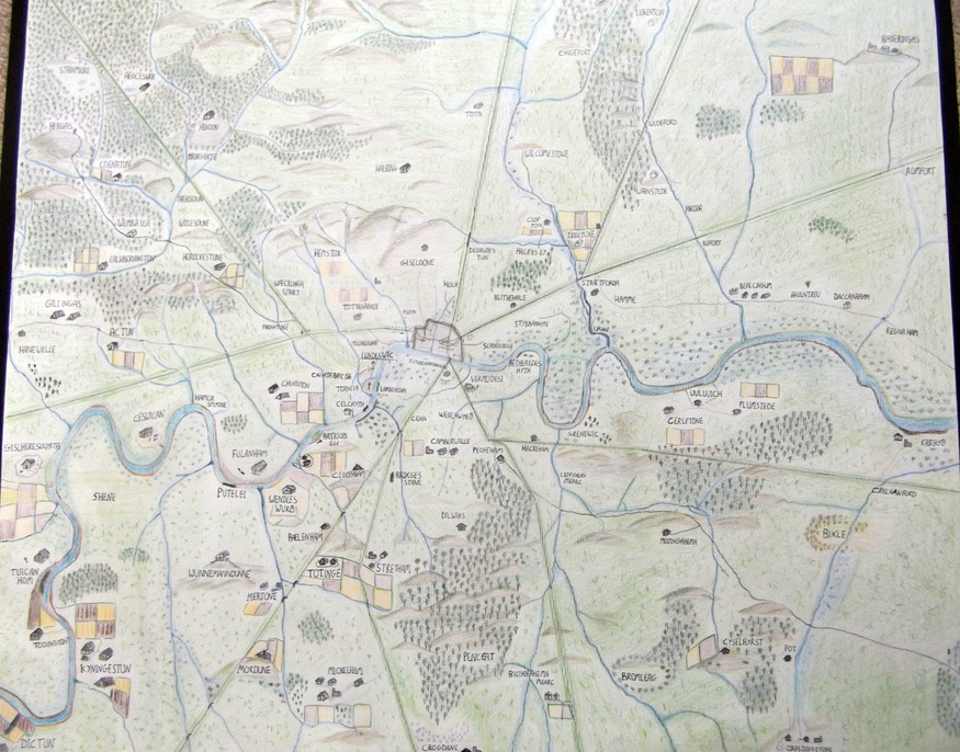
This modern map shows what Anglo-Saxon London may have looked like.
As well as showing the Anglo-Saxon centre, the map also includes many of the villages that surrounded it, with their earliest recorded names. Roman roads, which were still used but probably in ill repair, are also marked, as are tributaries of the Thames...
Hand-Drawn Maps: Anglo-Saxon London
By M@
Last edited 73 months ago
Londonist
Look around any map of London and you'll find the echoes of long-forgotten individuals. Cena, Padda, Fulla... ancient farmers who had no idea their names would live on down the centuries as Kennington, Paddington and Fulham.
Could the dairyman whose cheese farm (Ces wican) once graced the banks of the Thames have conceived that his humble business would live forever as Chiswick? People of Croydon: whatever happened to the valley of crocuses (Crogdene) after which your town is named? And who knew that the perennial football chant of 'Wember-ley, Wember-ley, Wember-ley' is actually pretty close to the area's original name of Wemba Lea (Wemba's forest clearing)?
We've never seen these Anglo-Saxon hamlets and farms mapped out before, so we thought we'd give it a go. The period shown covers 500-1050 AD, between the retreat of the Romans and the coming of the Normans. Once the Romans had cleared off, the area around Londinium was settled by a hotch-potch of Germanic peoples usually termed Anglo-Saxon. Their main trading port of Lundenwic was probably centred on what is now the Covent Garden and Aldwych (meaning 'old port') areas, but we know little about the full extent and organisation of this early London.

Much of east London round the river was given over to marsh land.

The full map.
Click here to see the full map in higher resolution: http://assets.londonist.com/uploads/2011/02/aswhole_6.jpg

Much of north-west London around the old Roman Watling Street would have been covered in forest

South-west London, showing the important royal settlement of Kyningestun (Kingston), meaning "the king's estate".

The Great North Wood, covering the Sydenham hills.

As well as showing the Anglo-Saxon centre, the map also includes many of the villages that surrounded it, with their earliest recorded names. Roman roads, which were still used but probably in ill repair, are also marked, as are tributaries of the Thames.
The extent of woodland at the time is more conjectural. The Anglo-Saxons are known to have felled large portions of forest, and the London area would not have been as woody as you might expect. Still, large expanses of trees, such as the Great North Wood around Sydenham, Epping Forest and the large Middlesex Forest to the north-west, were extant. We've also made a stab at showing areas of marsh and flood plain as well as hills around London, although these are imprecise.
Note also that the map covers a period of over 500 years. Not all the features shown on the map would have been present at the same time. And many additional settlements, and particularly Anglo-Saxon roads, are no doubt missing.
We'd welcome any feedback or suggestions for additions. We're not scholars, merely curious Londoners, so we expect to be corrected by those who've studied the period in more depth. Many sources were used to piece the map together, but the most useful were 'What's in a name?' by Cyril Harris and The Times History of London by Hugh Clout, which includes a sizeable gazetteer of name origins.
The deadline has now passed for submitting hand-drawn maps for consideration in our upcoming Museum of London exhibition. However, we will keep the series running on Londonist indefinitely. So please send your own creations to hello@londonist.com.
Hand-Drawn Maps: Anglo-Saxon London | Londonist
As well as showing the Anglo-Saxon centre, the map also includes many of the villages that surrounded it, with their earliest recorded names. Roman roads, which were still used but probably in ill repair, are also marked, as are tributaries of the Thames...
Hand-Drawn Maps: Anglo-Saxon London
By M@
Last edited 73 months ago
Londonist
Look around any map of London and you'll find the echoes of long-forgotten individuals. Cena, Padda, Fulla... ancient farmers who had no idea their names would live on down the centuries as Kennington, Paddington and Fulham.
Could the dairyman whose cheese farm (Ces wican) once graced the banks of the Thames have conceived that his humble business would live forever as Chiswick? People of Croydon: whatever happened to the valley of crocuses (Crogdene) after which your town is named? And who knew that the perennial football chant of 'Wember-ley, Wember-ley, Wember-ley' is actually pretty close to the area's original name of Wemba Lea (Wemba's forest clearing)?
We've never seen these Anglo-Saxon hamlets and farms mapped out before, so we thought we'd give it a go. The period shown covers 500-1050 AD, between the retreat of the Romans and the coming of the Normans. Once the Romans had cleared off, the area around Londinium was settled by a hotch-potch of Germanic peoples usually termed Anglo-Saxon. Their main trading port of Lundenwic was probably centred on what is now the Covent Garden and Aldwych (meaning 'old port') areas, but we know little about the full extent and organisation of this early London.

Much of east London round the river was given over to marsh land.

The full map.
Click here to see the full map in higher resolution: http://assets.londonist.com/uploads/2011/02/aswhole_6.jpg

Much of north-west London around the old Roman Watling Street would have been covered in forest

South-west London, showing the important royal settlement of Kyningestun (Kingston), meaning "the king's estate".

The Great North Wood, covering the Sydenham hills.

As well as showing the Anglo-Saxon centre, the map also includes many of the villages that surrounded it, with their earliest recorded names. Roman roads, which were still used but probably in ill repair, are also marked, as are tributaries of the Thames.
The extent of woodland at the time is more conjectural. The Anglo-Saxons are known to have felled large portions of forest, and the London area would not have been as woody as you might expect. Still, large expanses of trees, such as the Great North Wood around Sydenham, Epping Forest and the large Middlesex Forest to the north-west, were extant. We've also made a stab at showing areas of marsh and flood plain as well as hills around London, although these are imprecise.
Note also that the map covers a period of over 500 years. Not all the features shown on the map would have been present at the same time. And many additional settlements, and particularly Anglo-Saxon roads, are no doubt missing.
We'd welcome any feedback or suggestions for additions. We're not scholars, merely curious Londoners, so we expect to be corrected by those who've studied the period in more depth. Many sources were used to piece the map together, but the most useful were 'What's in a name?' by Cyril Harris and The Times History of London by Hugh Clout, which includes a sizeable gazetteer of name origins.
The deadline has now passed for submitting hand-drawn maps for consideration in our upcoming Museum of London exhibition. However, we will keep the series running on Londonist indefinitely. So please send your own creations to hello@londonist.com.
Hand-Drawn Maps: Anglo-Saxon London | Londonist
Last edited: