Punishing snowstorm predicted to pummel southern Ontario
Author of the article:
Brad Hunter
Publishing date:
Jan 16, 2022 • 6 hours ago • 1 minute read •
8 Comments
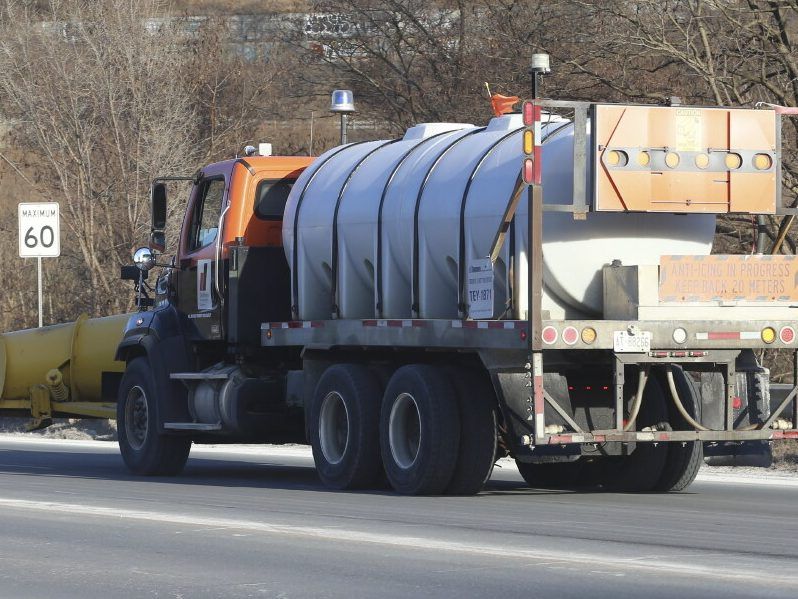
Snow plows and brine trucks were gearing up Sunday before a forecasted blizzard which threatened to make a mess of the morning commute.
Snow plows and brine trucks were gearing up Sunday before a forecasted blizzard which threatened to make a mess of the morning commute. Photo by Jack Boland /Toronto Sun
Article content
The Big Smoke and huge swaths of southern Ontario are poised to be pummeled by up to 40 centimetres of snow.
Advertisement
Story continues below
Article content
Environment Canada says the blizzard-like buffet of brutal weather will likely make the Monday morning commute a snowy nightmare triggering dangerous driving conditions.
The snow was slated to start falling Sunday night and expected to “spread rapidly northeastward through the day Monday.”
“Consider postponing non-essential travel until conditions improve. Surfaces such as highways, roads, walkways and parking lots may become difficult to navigate due to accumulating snow. Visibility may be suddenly reduced at times in heavy snow,” Environment and Climate Change Canada (ECCC) said in their winter storm warning.
ECCC also advises people to be cautious when shoveling snow.
Snow is expected to fall heavily at with a few centimetres an hour possible at some points, along with winds in the area of 50 km/h Monday afternoon, straining visibility.
Advertisement
Story continues below
Article content
“Travel will likely be difficult due to the expected heavy snow,” Environment Canada said.
Niagara and the Hamilton area are expected to be hardest hit.
The snowfall will continue into Monday morning before eventually tapering off later in the day.
In Toronto, ECCC said snowfall accumulations are guesstimated to be between 10 centimetres and 20 centimetres, although “higher amounts can’t be ruled out.”
Although Ontario students were slated to return to class Monday, the Toronto District School Board issued a warning that schools could be closed and classes moved online for the day as part of its severe weather procedures.
An update was expected Monday at 6 a.m., its website said.
As for the rest of the week, winter conditions and temperatures will prevail. The Weather Network said the thermometer will be near seasonal or slightly colder.
Forecast calls for a clipper to hit late Tuesday and into Wednesday, followed by another blast of frigid Arctic air for Thursday and Friday.
bhunter@postmedia.com
@HunterTOSun
 torontosun.com
Author of the article:
Brad Hunter
Publishing date:
Jan 16, 2022 • 6 hours ago • 1 minute read •
8 Comments
Snow plows and brine trucks were gearing up Sunday before a forecasted blizzard which threatened to make a mess of the morning commute.
Snow plows and brine trucks were gearing up Sunday before a forecasted blizzard which threatened to make a mess of the morning commute. Photo by Jack Boland /Toronto Sun
Article content
The Big Smoke and huge swaths of southern Ontario are poised to be pummeled by up to 40 centimetres of snow.
Advertisement
Story continues below
Article content
Environment Canada says the blizzard-like buffet of brutal weather will likely make the Monday morning commute a snowy nightmare triggering dangerous driving conditions.
The snow was slated to start falling Sunday night and expected to “spread rapidly northeastward through the day Monday.”
“Consider postponing non-essential travel until conditions improve. Surfaces such as highways, roads, walkways and parking lots may become difficult to navigate due to accumulating snow. Visibility may be suddenly reduced at times in heavy snow,” Environment and Climate Change Canada (ECCC) said in their winter storm warning.
ECCC also advises people to be cautious when shoveling snow.
Snow is expected to fall heavily at with a few centimetres an hour possible at some points, along with winds in the area of 50 km/h Monday afternoon, straining visibility.
Advertisement
Story continues below
Article content
“Travel will likely be difficult due to the expected heavy snow,” Environment Canada said.
Niagara and the Hamilton area are expected to be hardest hit.
The snowfall will continue into Monday morning before eventually tapering off later in the day.
In Toronto, ECCC said snowfall accumulations are guesstimated to be between 10 centimetres and 20 centimetres, although “higher amounts can’t be ruled out.”
Although Ontario students were slated to return to class Monday, the Toronto District School Board issued a warning that schools could be closed and classes moved online for the day as part of its severe weather procedures.
An update was expected Monday at 6 a.m., its website said.
As for the rest of the week, winter conditions and temperatures will prevail. The Weather Network said the thermometer will be near seasonal or slightly colder.
Forecast calls for a clipper to hit late Tuesday and into Wednesday, followed by another blast of frigid Arctic air for Thursday and Friday.
bhunter@postmedia.com
@HunterTOSun
Punishing snowstorm predicted to pummel southern Ontario
The Big Smoke and huge swaths of southern Ontario are poised to be pummeled by up to 40 centimetres of snow.
![icanteven-slippery[1].gif](https://forums.canadiancontent.net/data/attachments/9/9961-aa8a0c0f19cb00ef80a79d191947e54d.jpg "icanteven-slippery[1].gif")


