How the Elizabethans viewed their world
Dalya Alberge, Arts Correspondent
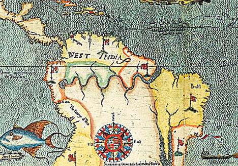
Elizabethan: Sir Francis Drake's South America
An historic copy of the first printed atlas of England and Wales, a landmark in Elizabethan cartography, is coming on to the market for the first time in 200 years.
Printed between 1579 and 1590, it showed the country’s geography in its entirety for the first time.
It was produced by Christopher Saxton, a surveyor from Yorkshire and the father of English cartography.
Nine of the ten surviving copies are held in institutional libraries. This one, a previously unrecorded example that has been owned by the Earls of Macclesfield, is arguably the finest example to have come to the market.
Bound into the atlas is an extremely rare and important set of five charts, engraved by Giovanni Battista Boazio. They illustrate Sir Francis Drake’s famous expedition to the West Indies and America from 1585 to 1586, when he set out to attack the Spanish possessions there.
This set of charts, depicting towns “visited” by Drake’s fleet, are of particular importance because they gave Elizabethan England the first glimpse of America. Among the charts is a view of St Augustine in northern Florida — the earliest printed view of any city in North America.
The volume also includes the first printed appearance of any American natural history subjects, based on drawings by John White, an artist and the Governor of the first English colony on Roanoke Island, North Carolina, and is estimated to fetch about £700,000 when sold at Sotheby’s in London on March 15.
Catherine Slowther, Sotheby’s maps and atlases specialist, said: “This volume has remained almost untouched for over 200 years, perfectly preserving its hand-coloured plates.
In my 20 years as a maps and atlases specialist at Sotheby’s, I have never handled a set of these charts, nor a finer example of Saxton’s atlas.” Not only is this hugely detailed atlas the first to map England and Wales, it is also the first atlas of any country to map individual counties.
It is thought to have been commissioned by William Burghley — and indirectly by Elizabeth I — not only to celebrate the richness of the land she ruled, but also to chart the locations of potentially threatening Roman Catholic estates.
The atlas is in remarkable condition. Adding considerably to its rarity is the inclusion of a engraved portrait of Elizabeth I in contemporary hand colour, one of the finest of all engraved portraits of the Queen.
Together, the Saxton and Boazio maps provide a remarkable record of the emerging national identity of Tudor England and her ambition to take her place on the world stage.
The set includes the first printed views of Santiago (Cape Verde Islands) and other places in the region. The charts by Boazio feature a general route through the North Atlantic.
dailymail.co.uk
Dalya Alberge, Arts Correspondent
Elizabethan: Sir Francis Drake's South America
An historic copy of the first printed atlas of England and Wales, a landmark in Elizabethan cartography, is coming on to the market for the first time in 200 years.
Printed between 1579 and 1590, it showed the country’s geography in its entirety for the first time.
It was produced by Christopher Saxton, a surveyor from Yorkshire and the father of English cartography.
Nine of the ten surviving copies are held in institutional libraries. This one, a previously unrecorded example that has been owned by the Earls of Macclesfield, is arguably the finest example to have come to the market.
Bound into the atlas is an extremely rare and important set of five charts, engraved by Giovanni Battista Boazio. They illustrate Sir Francis Drake’s famous expedition to the West Indies and America from 1585 to 1586, when he set out to attack the Spanish possessions there.
This set of charts, depicting towns “visited” by Drake’s fleet, are of particular importance because they gave Elizabethan England the first glimpse of America. Among the charts is a view of St Augustine in northern Florida — the earliest printed view of any city in North America.
The volume also includes the first printed appearance of any American natural history subjects, based on drawings by John White, an artist and the Governor of the first English colony on Roanoke Island, North Carolina, and is estimated to fetch about £700,000 when sold at Sotheby’s in London on March 15.
Catherine Slowther, Sotheby’s maps and atlases specialist, said: “This volume has remained almost untouched for over 200 years, perfectly preserving its hand-coloured plates.
In my 20 years as a maps and atlases specialist at Sotheby’s, I have never handled a set of these charts, nor a finer example of Saxton’s atlas.” Not only is this hugely detailed atlas the first to map England and Wales, it is also the first atlas of any country to map individual counties.
It is thought to have been commissioned by William Burghley — and indirectly by Elizabeth I — not only to celebrate the richness of the land she ruled, but also to chart the locations of potentially threatening Roman Catholic estates.
The atlas is in remarkable condition. Adding considerably to its rarity is the inclusion of a engraved portrait of Elizabeth I in contemporary hand colour, one of the finest of all engraved portraits of the Queen.
Together, the Saxton and Boazio maps provide a remarkable record of the emerging national identity of Tudor England and her ambition to take her place on the world stage.
The set includes the first printed views of Santiago (Cape Verde Islands) and other places in the region. The charts by Boazio feature a general route through the North Atlantic.
dailymail.co.uk